Home
View All Services Boundary Survey Property Survey SRPR Survey Building Permit Survey Topographic Survey Grading & Site Plan Construction Layout As-Built Survey LiDAR & 3D Scanning Drone & UAV Mapping
About Us
View All Articles Survey Guides Survey Costs Building Permits GTA Municipality Guides Property & Real Estate
Contact Us
Get a Free Quote
LiDAR & 3D Scanning — Greater Toronto Area

LiDAR & 3D Scanning
Across the GTA

Ultra-precise LiDAR and 3D laser scanning services conducted by licensed OLS professionals on our team. Capturing millions of data points with millimetre accuracy — for complex sites, large properties, and advanced survey needs across the Greater Toronto Area.

Licensed OLS Team
Millimetre Accuracy
All GTA Municipalities
Point Cloud Delivery

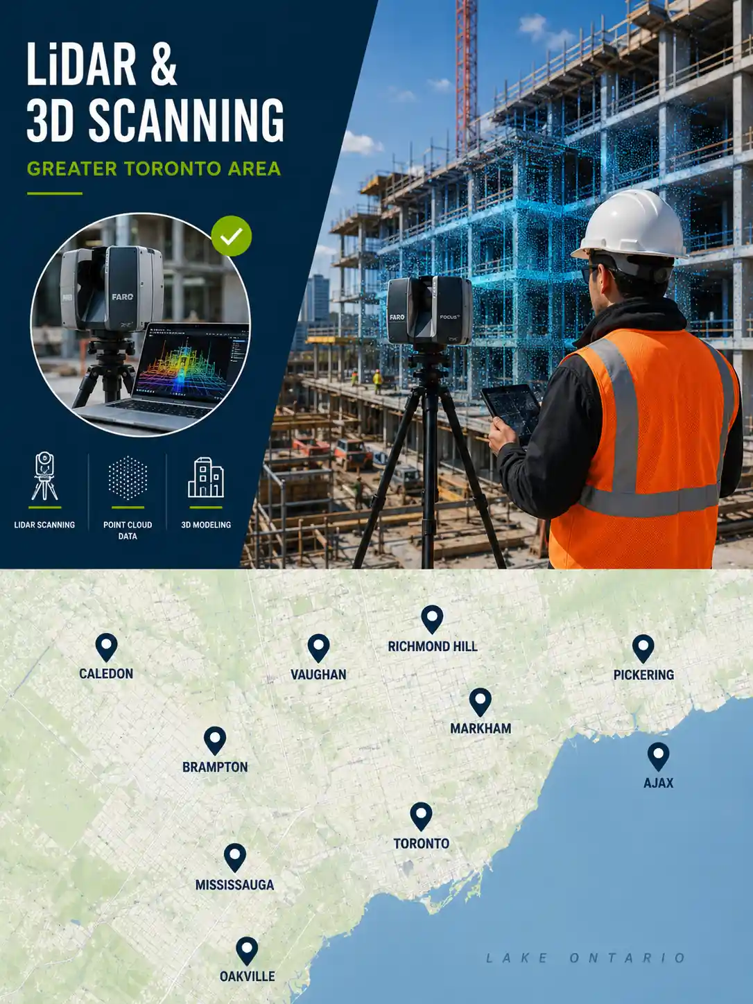
What is LiDAR & 3D Scanning?

The Most Advanced Survey Technology Available in the GTA

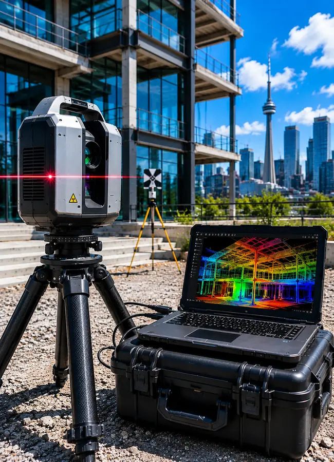
LiDAR (Light Detection and Ranging) and 3D laser scanning is a cutting-edge survey technology that captures millions of precise data points per second — creating ultra-detailed three-dimensional point cloud models of any structure, site, or environment.

How our technology works

Our licensed OLS professionals use state-of-the-art terrestrial LiDAR scanners to capture complete 3D representations of buildings, infrastructure, construction sites, and properties across the GTA with millimetre accuracy — delivering data that traditional survey methods simply cannot match in speed, detail, or completeness.

From heritage building documentation and structural monitoring to complex industrial facility mapping and large-scale site surveys across Toronto, Mississauga, Brampton, Markham, and all GTA municipalities — our LiDAR and 3D scanning services provide the advanced spatial data your project needs.

±2mm Scan Accuracy
1M+ Points Per Second
360° Full Coverage

Millimetre accuracy point cloud data

Captures millions of precise data points delivering detail impossible with traditional survey methods.

Licensed OLS professionals on our team

Every scan is managed by licensed Ontario Land Surveyors ensuring legal compliance and accuracy.

Full 3D point cloud & CAD deliverables

Receive complete point cloud data, 3D models, and CAD files ready for your engineering team.

LiDAR 3D scanning survey GTA Toronto Ontario licensed OLS professionals

Who Needs This

Who Needs LiDAR & 3D Scanning?

LiDAR and 3D scanning is used across a wide range of industries and project types where precision, speed, and detail go beyond what traditional survey methods can deliver.

Architecture

Architects & Building Documentation

Architects across the GTA use LiDAR scanning to create precise as-built documentation of existing buildings for renovation, heritage preservation, and adaptive reuse projects — capturing every detail faster and more accurately than traditional field measurements.

Engineering

Structural & Civil Engineers

Structural and civil engineers rely on 3D scan data for structural analysis, deformation monitoring, clash detection, and complex infrastructure documentation — providing a level of spatial detail impossible to achieve with conventional survey methods.

Construction

Construction & Project Managers

Construction managers use LiDAR scanning for progress monitoring, quality control, clash detection, and as-built documentation on complex projects across the GTA — comparing scan data against BIM models to identify issues before they become costly problems.

Heritage

Heritage Building Preservation

Heritage preservation professionals and municipalities across Ontario use LiDAR scanning to create permanent digital records of historic buildings and structures — capturing intricate architectural details for restoration, documentation, and conservation purposes.

Industrial

Industrial Facility Mapping

Industrial facilities, manufacturing plants, and process facilities across the GTA use 3D scanning to document complex pipe networks, equipment layouts, and structural systems — supporting plant expansions, modifications, and maintenance planning.

Infrastructure

Infrastructure & Transportation

Transportation agencies, utilities, and infrastructure owners across the GTA use LiDAR scanning for bridge inspections, corridor mapping, tunnel documentation, and condition assessment — delivering comprehensive spatial data for planning and maintenance.

Not sure if LiDAR scanning is right for your project? Our team will help you choose the right survey technology.

Talk to Our Team

What You Receive

Everything Included in Your LiDAR & 3D Scanning Service

Every LiDAR and 3D scanning engagement delivered by our licensed OLS team includes complete scan data, processed deliverables, and certified documentation — all in your quoted price with no hidden fees.

±2mm Scan Accuracy
1M+ Points Per Second
360° Full Coverage

Field Scanning

Terrestrial LiDAR Scanning

High-density terrestrial laser scanning capturing millions of precise 3D data points across your entire site or structure.

360° Site Coverage

Complete 360° scanning coverage from multiple scan positions ensuring no blind spots or gaps in your point cloud data.

RGB Colour Capture

High-resolution colour photography integrated with scan data to create fully colourized point clouds for enhanced visualization.

Data Processing

Point Cloud Registration

Professional registration and alignment of all scan positions into a single unified coordinate system for your project.

Noise Filtering & Cleaning

Complete point cloud noise filtering and cleaning to remove unwanted data and deliver a clean accurate dataset.

3D Model Generation

Generation of 3D mesh models, surface models, and BIM-ready content from your processed point cloud data.

Deliverables

Full Point Cloud Dataset

Complete registered and processed point cloud data in industry-standard formats including LAS, E57, and RCP.

2D CAD Drawings

Accurate 2D floor plans, elevations, and sections extracted from scan data and delivered in DWG and PDF formats.

OLS Certified Reports

All survey documentation signed and sealed by licensed Ontario Land Surveyors on our team for legal compliance.

±2mm

Scan Accuracy

360°

Full Site Coverage

CAD

& BIM Ready

OLS

Certified Team

How It Works

Your LiDAR & 3D Scanning
Project in 5 Steps

From consultation to final delivery

Our licensed OLS team manages every step of your LiDAR scanning project with precision and efficiency across the GTA — no surprises, no hidden fees.

5 Simple
Steps
Get Your Free Quote
Step 01

Project Consultation & Scope

We review your requirements, site conditions, and deliverable needs — then provide a clear upfront quote with no hidden fees.

Same day
Step 02

Site Assessment & Scan Planning

Our OLS team plans optimal scanner positions and prepares control survey data to georegister your point cloud accurately.

1–2 days
Step 03

LiDAR Field Scanning

We mobilize to your site and capture millions of data points at ±2mm accuracy with full 360° coverage using state-of-the-art equipment.

Half–full day
Step 04

Data Processing & Model Generation

Scan data is registered and processed into a unified point cloud. 3D models and CAD drawings are generated by our expert team.

3–7 days
Step 05

Deliverable Handoff & Support

Receive your complete package — point cloud files, CAD, 3D models, and OLS certified reports. Ongoing support included.

5–15 days total

Ready to start your LiDAR scanning project? Get a free quote from our licensed OLS team today.

Get Your Free Quote

Why Choose Us

The GTA's Trusted LiDAR & 3D Scanning Team

Engineers, architects, developers, and project managers across the GTA rely on our licensed OLS team for LiDAR and 3D scanning services that deliver the precision, speed, and data quality their projects demand.

Get Your Free Quote

State-of-the-Art LiDAR Equipment

We use the latest generation terrestrial LiDAR scanners delivering ±2mm accuracy and over 1 million points per second — capturing the level of detail that complex architectural, engineering, and construction projects require.

±2mm Accuracy

Licensed OLS Professionals on Our Team

All LiDAR scanning engagements are managed by licensed Ontario Land Surveyors on our team — ensuring all control survey work, coordinate systems, and certified documentation meet Ontario survey standards and legal requirements.

OLS Certified

Complete Deliverable Package

We deliver everything your project team needs — registered point cloud data in industry-standard formats, 2D CAD drawings, 3D models, and BIM-ready content — all processed by our experienced team and ready to use immediately.

BIM Ready

All GTA Municipalities & Project Types

We provide LiDAR and 3D scanning services across all GTA municipalities — from single building documentation in Toronto to large infrastructure projects in Mississauga, Brampton, Markham, and all surrounding communities.

20+ GTA Cities

Ready to get started with LiDAR & 3D Scanning?

Our licensed OLS team is ready to discuss your project requirements and provide a free quote — no obligation, no hidden fees.

Service Areas

LiDAR & 3D Scanning Across All GTA Municipalities

Our licensed OLS team mobilizes to any site across the Greater Toronto Area — delivering precise LiDAR and 3D scanning services for buildings, infrastructure, and complex sites of any size.

Toronto
Mississauga
Brampton
Markham
Vaughan
Richmond Hill
Oakville
Burlington
Pickering
Ajax
Whitby
Oshawa
Aurora
Newmarket
Milton
Halton Hills

Currently serving all GTA municipalities

Check Your Area
LiDAR 3D scanning service areas GTA Toronto Ontario licensed OLS
±2mm Accuracy
20+ GTA Cities
±2mm Accuracy
OLS Certified

FAQ

Frequently Asked Questions About LiDAR & 3D Scanning

Have questions about LiDAR and 3D scanning services in the GTA? We have answers. Our licensed OLS team is happy to discuss your specific project requirements.

9 Questions Answered
±2mm Scan Accuracy
Point Cloud Delivery
BIM Ready Output
OLS Certified Team
Call Our Team

What is LiDAR scanning and how does it work?

LiDAR (Light Detection and Ranging) scanning works by emitting millions of laser pulses per second and measuring the time it takes for each pulse to return after bouncing off a surface. This creates a dense three-dimensional point cloud — a precise digital representation of your structure or site with accuracy of ±2mm. Our licensed OLS team uses this data to produce detailed 3D models, CAD drawings, and certified survey documentation.

What is the accuracy of your LiDAR scanning service?

Our terrestrial LiDAR scanners achieve point cloud accuracy of ±2mm — capturing over 1 million data points per second with full 360° coverage. This level of precision far exceeds what traditional survey methods can achieve and is suitable for the most demanding architectural, engineering, and construction applications across the GTA.

What deliverables do I receive from a LiDAR scan?

Our standard LiDAR scanning deliverables include a fully registered and processed point cloud dataset in industry-standard formats (LAS, E57, RCP), 2D CAD drawings including floor plans, elevations, and sections, 3D mesh models, and OLS certified reports signed and sealed by licensed Ontario Land Surveyors on our team. We can also provide BIM-ready content and custom deliverables based on your project requirements.

How long does a LiDAR scanning project take?

The duration of a LiDAR scanning project depends on the size and complexity of your site or structure. Field scanning typically takes one to several days depending on site size. Data processing and deliverable generation adds additional time — most projects are completed and delivered within 5–15 business days from field mobilization. We provide a clear timeline estimate during the project consultation phase.

What is the difference between LiDAR scanning and a traditional survey?

A traditional survey captures specific discrete measurements of key points. LiDAR scanning captures millions of data points simultaneously — creating a complete digital replica of the entire environment. LiDAR is faster for large or complex sites, captures far more detail, reduces on-site time, and produces 3D deliverables that traditional surveys cannot. Our licensed OLS team combines both technologies to provide the right solution for each project.

Can LiDAR scan data be used for BIM modelling?

Yes — our LiDAR scan deliverables are fully compatible with BIM workflows. We deliver point cloud data in formats compatible with Autodesk Revit, AutoCAD, Navisworks, and other leading BIM platforms. Our team can also assist with scan-to-BIM workflows, producing BIM-ready content directly from the point cloud data for your architecture or engineering team.

What types of projects is LiDAR scanning suitable for?

LiDAR scanning is suitable for a wide range of projects including building documentation for renovation and heritage preservation, structural monitoring, construction progress documentation, industrial facility mapping, infrastructure inspection, complex site surveys, clash detection for MEP coordination, and any project requiring highly detailed 3D spatial data across the GTA.

How much does LiDAR scanning cost in the GTA?

The cost of LiDAR scanning in the GTA depends on the size and complexity of your site or structure, the number of scan positions required, and the deliverables needed. We provide free transparent quotes with no hidden fees before any work begins. Contact us with your project details for an accurate upfront quote.

Do you serve all cities across the Greater Toronto Area?

Yes — we provide LiDAR and 3D scanning services across all GTA municipalities including Toronto, Mississauga, Brampton, Markham, Vaughan, Richmond Hill, Oakville, Burlington, Pickering, Ajax, Whitby, Oshawa, Aurora, Newmarket, Milton, and Halton Hills. Our team mobilizes to any site across the region.

Related Services

Other Survey Services You May Need

We offer a full range of advanced survey services across the GTA. Explore other services commonly used alongside LiDAR and 3D scanning.
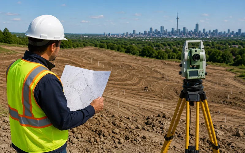
Topographic survey GTA Toronto Ontario licensed OLS Topographic Survey Traditional Method ✅

Topographic Survey

Need elevation and contour data without the full LiDAR package? Our topographic surveys deliver precise grade and elevation documentation using traditional total station methods — fast, cost-effective, and accepted by all GTA municipalities.
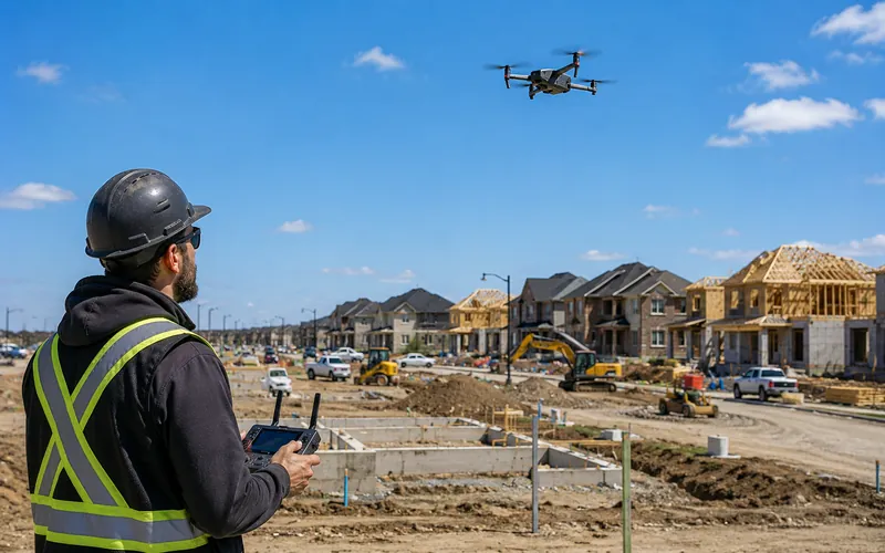
Drone UAV mapping survey GTA Toronto Ontario licensed OLS Drone/UAV Mapping Aerial Option ✅

Drone & UAV Mapping

Need aerial data capture for large sites or hard-to-access areas? Our drone and UAV mapping services complement LiDAR scanning by providing high-resolution aerial imagery, photogrammetry, and topographic data from above across the GTA.
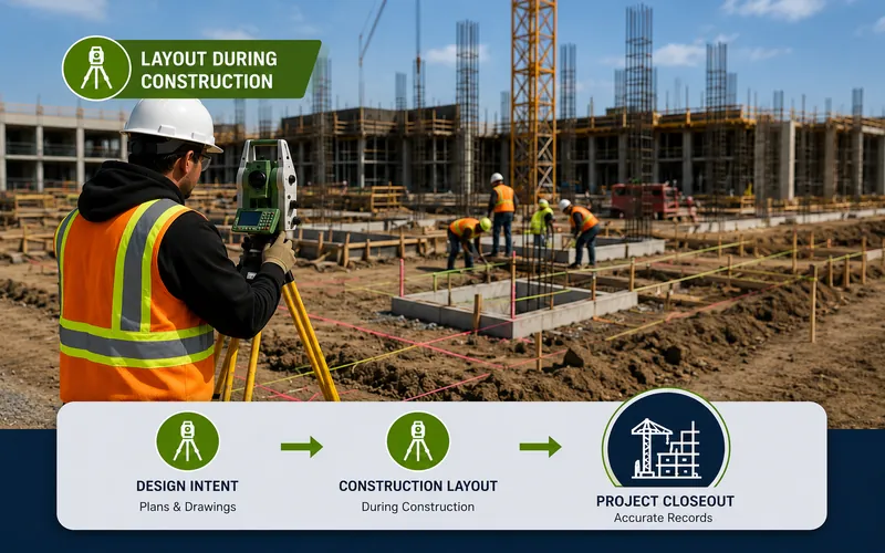
Construction layout site control GTA Toronto Ontario licensed OLS Construction Layout Often Combined ✅

Construction Layout & Site Control

LiDAR scan data is often used alongside construction layout services for complex projects — providing the as-built reference data that our licensed OLS team uses to verify layout accuracy throughout the construction process.

We offer 10 professional survey services across all GTA municipalities — one trusted licensed OLS team for every project.

Get Started Today

Ready to Get Started with
LiDAR & 3D Scanning?

Get a free quote from our licensed OLS team — we will review your project requirements and recommend the right scanning approach for your site and budget across the GTA.

±2mm Scan Accuracy
1M+ Points / Second
360° Full Coverage
BIM Ready Output
Scroll to Top